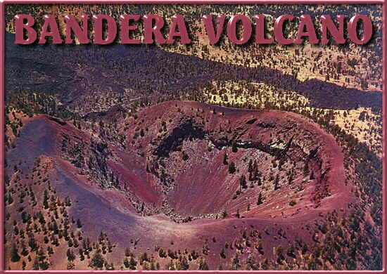
U.S. Show Caves Directory


Ice Cave & Bandera Volcano


"Where volcanic craters and sinuous lava tubes compare with the lunar landscape..."


Bandera Volcano | Lava Tubes | Ice Cave | How to Get There | For More Information


For a real experience in contrast, visit the Land of Fire and Ice. Situated on the Continental Divide among ponderosa pines at an elevation of almost 8,000 feet, the Bandera Volcano-Ice Cave area has been called "the most moon-like expanse of country on Earth".

Bandera Volcano

Bandera Crater is the largest volcano in the region. It erupted around 10,000 years ago. There were two stages of the eruption: first the cinder cone developed, then a massive lava flow broke out on its side. The molten lava reached temperatures above 2,000 degrees Fahrenheit. Bandera's lava flow is nearly 23 miles long.

At the end of the Bandera eruption, the lava suddenly fell back down the main vent making the bottom of the cone deeper than the outside lava flow. The crater that remains is nearly 1200 feet wide at the top and roughly 750 feet deep. Over time, erosion and gravity take their toll on the crater and slowly fill it with cinders and rocks.
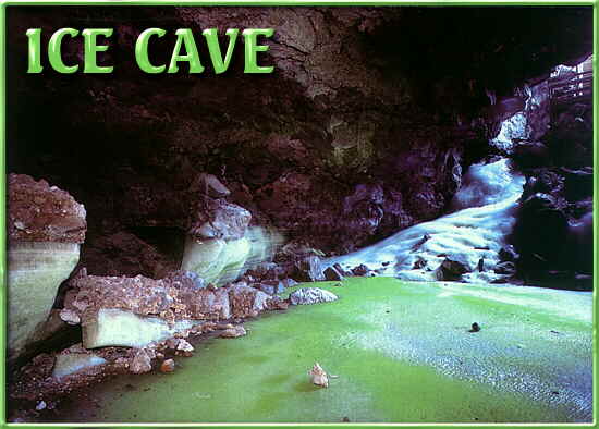
Lava Tubes

The Bandera lava tube complex at one time extended for over seventeen miles. Today, much of the tube is collapsed, but many segments of these spectacular caves remain to be seen.

The Bandera lava tubes formed during the phase of molten lava flow from the volcano. The surface of the lava hardened, while below, the lava continued to flow. The hardened, porous lava acted as an excellent insulator and kept the lava beneath the surface hot and runny. The insulated lava so flowed through natural pipelines appropriately known as lava tubes. When the flow from Bandera came to an end, the lava tubes drained and left caves that we can explore today.

Ice Cave

The Ancient Lava Trail leads you to Ice Cave, the partially collapsed remains of a lava tube. The temperature at Ice Cave never rises above 31 degrees Fahrenheit. It is floored with natural layers of perpetual ice that glisten blue-green in the reflected rays of sunlight. The green tint is caused by unusual forms of Arctic algae.

As rain water and snowmelt seep into this cave, the ice floor thickens. The floor of the ice is now approximately 20 feet thick. The deepest ice is the oldest and dates back to the year 170 AD. The back wall was carved in the early days when Pueblo Indians, who knew the cave as the "Winter Lake", and early settlers mined the ice. In 1946, ice removal was stopped, at which time the ice wall was nearly 12 feet high. Since then, the ice floor has risen relative to the back wall. The rate of ice accumulation varies with annual precipitation.

Ice Cave serves as a natural ice box due to its peculiar geometry. A restricted entrance leads downward twenty feet into an enclosed chamber. During the winter, cold, dense air sinks into the cave. During the summer, little air exchange takes place, and the cave is insulated from the sun's heat by porous lava rock. The cave thus maintains frigid winter temperatures all year round.

How to Get There

For More Information

Contact the management by e-mail at davecand@aol.com.

Please visit our other home page at www.icecaves.com.


top home usa map state map


©1996